


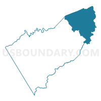
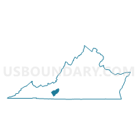
Locust Grove Voting District, Floyd County, Virginia
About
Outline

Summary
| Unique Area Identifier | 681674 |
| Name | Locust Grove Voting District |
| County | Floyd County |
| State | Virginia |
| Area (square miles) | 65.14 |
| Land Area (square miles) | 65.09 |
| Water Area (square miles) | 0.04 |
| % of Land Area | 99.93 |
| % of Water Area | 0.07 |
| Latitude of the Internal Point | 37.05751610 |
| Longtitude of the Internal Point | -80.19814790 |
Maps

Graphs
Select a template below for downloading or customizing gragh for Locust Grove Voting District, Floyd County, Virginia


Neighbors
Neighoring Voting District (by Name) Neighboring Voting District on the Map
- Bent Mountain Voting District, Roanoke County, VA
- Bowmans Voting District, Franklin County, VA
- C-1 Voting District, Montgomery County, VA
- Callaway Voting District, Franklin County, VA
- D-4 Voting District, Montgomery County, VA
- Endicott Voting District, Franklin County, VA
- Little River Voting District, Floyd County, VA
Top 10 Neighboring County Subdivision (by Population) Neighboring County Subdivision on the Map
- Windsor Hills district, Roanoke County, VA (18,206)
- District D-01, Montgomery County, VA (13,543)
- District C-01, Montgomery County, VA (12,847)
- Blackwater district, Franklin County, VA (7,675)
- Blue Ridge district, Franklin County, VA (7,574)
- Little River district, Floyd County, VA (3,339)
- Locust Grove district, Floyd County, VA (2,902)
Top 10 Neighboring Unified School District (by Population) Neighboring Unified School District on the Map
- Montgomery County Public Schools, VA (94,392)
- Roanoke County Public Schools, VA (92,376)
- Franklin County Public Schools, VA (56,159)
- Floyd County Public Schools, VA (15,279)
Top 10 Neighboring State Legislative District Lower Chamber (by Population) Neighboring State Legislative District Lower Chamber on the Map
- State House District 9, VA (82,064)
- State House District 7, VA (75,999)
- State House District 8, VA (74,460)
Top 10 Neighboring State Legislative District Upper Chamber (by Population) Neighboring State Legislative District Upper Chamber on the Map
- State Senate District 22, VA (193,582)
- State Senate District 19, VA (186,272)
- State Senate District 20, VA (177,184)
Top 10 Neighboring 111th Congressional District (by Population) Neighboring 111th Congressional District on the Map
Top 10 Neighboring Census Tract (by Population) Neighboring Census Tract on the Map
- Census Tract 205, Franklin County, VA (8,135)
- Census Tract 306, Roanoke County, VA (7,298)
- Census Tract 9201.01, Floyd County, VA (6,177)
- Census Tract 214, Montgomery County, VA (5,103)
- Census Tract 206, Franklin County, VA (3,774)
- Census Tract 9201.02, Floyd County, VA (3,753)
Top 10 Neighboring 5-Digit ZIP Code Tabulation Area (by Population) Neighboring 5-Digit ZIP Code Tabulation Area on the Map
- 24091, VA (7,215)
- 24088, VA (5,408)
- 24162, VA (2,421)
- 24067, VA (2,230)
- 24079, VA (1,766)
- 24138, VA (1,613)
- 24072, VA (1,298)
- 24059, VA (872)